自転車ルートプラン・標高グラフ・地形地図 | GCYCON 23.08.28.5
Free Version
Publisher Description

自転車ルートプラン・標高グラフ・地形地図 | GCYCON - [For Yuru Pota] You can use the speedometer, route creation, and simple navigation functions. It is easy to plan the route in advance with the topographic map and street view.
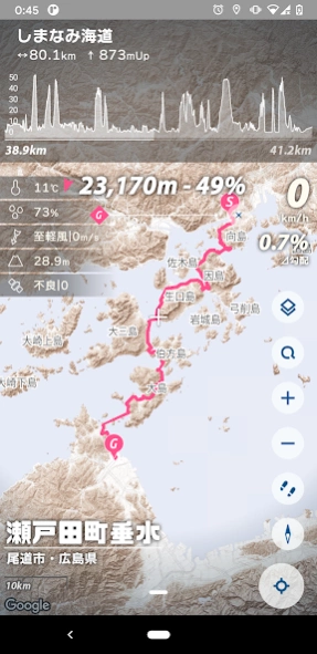
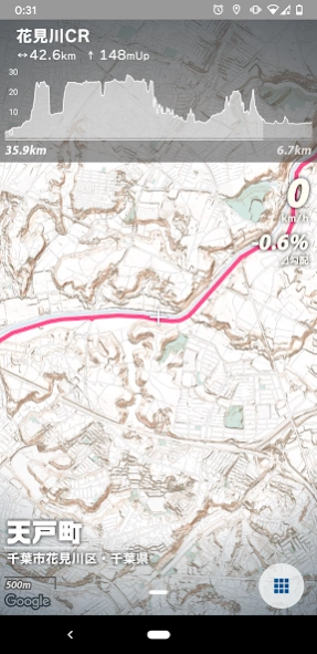
It is mainly a utility tool for bicycles, and you can use functions such as speedometer, track recording, and route creation that allows you to check the altitude graph. You can intuitively see the height difference with the original terrain tile. A little exploratory feeling is produced even for casual movements.
o Main features
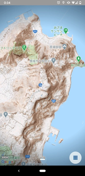
Unique terrain tiles that allow you to intuitively understand the terrain
Record route, altitude and speed as a GPS logger
Route creation, elevation graph display
Simple navigation that shows the distance and direction to the destination
Supports north up and heading up
Display of sun direction, sunset, and sunrise direction
Display of weather information such as temperature, wind speed, and wind direction
Includes sample routes of the National Cycle Route (Shimanami Kaido, Biwaichi, Tsukuba Kasumigaura Rinrin Road)
o Usage
Cycling, pottering, long rides, wheeling, mini velo, cross bikes, road bikes, bicycles, bicycle trips, scatter, walks, walks, trips, microtourism, speed meters, trackers, GPS loggers, historic sites, shrines and temples, cafe activities .. .. And so on
Since you can see the terrain and altitude, you will be more aware of disaster prevention.
o Precautions and disclaimers when using
It is very dangerous to use while driving or walking. Please use with caution.
The developer is not responsible for any damage caused to the user by using this application.
The app may not be able to be provided due to changes in the specifications of the API used.
The bike route display is in beta. The routes in the search results may contain roads that are not suitable for biking.
Regarding peripheral search, route search, and street view, we may ask for a limited number of times or support in the future.
o license
Geospatial Information Authority of Japan basic map information (approval number Hei 28 ambassador, No. 740)
Hyogo Prefecture_Whole area numerical topographic map_Portal (2010-2018)
Geospatial Information Authority of Japan elevation API
YOLP elevation API
Google Maps API
Mapbox API
MPAndroidChart
android-gpx-parser
Glide
Joda-Time
o Reference
Geospatial Information Authority of Japan "Geographical Survey Map (Standard Map)"
Japan Meteorological Agency website
Ko Nagasawa "Calculation of sunrise and sunset"
o Contact us
nrmeika@gmail.com
About 自転車ルートプラン・標高グラフ・地形地図 | GCYCON
自転車ルートプラン・標高グラフ・地形地図 | GCYCON is a free app for Android published in the Geography list of apps, part of Education.
The company that develops 自転車ルートプラン・標高グラフ・地形地図 | GCYCON is norameika!. The latest version released by its developer is 23.08.28.5.
To install 自転車ルートプラン・標高グラフ・地形地図 | GCYCON on your Android device, just click the green Continue To App button above to start the installation process. The app is listed on our website since 2023-08-28 and was downloaded 1 times. We have already checked if the download link is safe, however for your own protection we recommend that you scan the downloaded app with your antivirus. Your antivirus may detect the 自転車ルートプラン・標高グラフ・地形地図 | GCYCON as malware as malware if the download link to com.norameika.capibara is broken.
How to install 自転車ルートプラン・標高グラフ・地形地図 | GCYCON on your Android device:
- Click on the Continue To App button on our website. This will redirect you to Google Play.
- Once the 自転車ルートプラン・標高グラフ・地形地図 | GCYCON is shown in the Google Play listing of your Android device, you can start its download and installation. Tap on the Install button located below the search bar and to the right of the app icon.
- A pop-up window with the permissions required by 自転車ルートプラン・標高グラフ・地形地図 | GCYCON will be shown. Click on Accept to continue the process.
- 自転車ルートプラン・標高グラフ・地形地図 | GCYCON will be downloaded onto your device, displaying a progress. Once the download completes, the installation will start and you'll get a notification after the installation is finished.
